
Thank you for supporting this site ❤️
Make a donation
Make a donation
Hastings County topographic map
Click on the map to display elevation.
Thank you for supporting this site ❤️
Make a donation
Make a donation
About this map
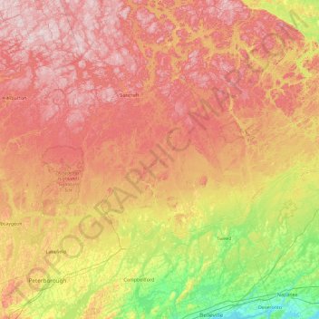
Name: Hastings County topographic map, elevation, terrain.
Location: Hastings County, Central Ontario, Ontario, Canada (44.14764 -78.17764 45.43808 -77.03308)
Average elevation: 288 m
Minimum elevation: 72 m
Maximum elevation: 545 m
Thank you for supporting this site ❤️
Make a donation
Make a donation
Other topographic maps
Click on a map to view its topography, its elevation and its terrain.
Thank you for supporting this site ❤️
Make a donation
Make a donation
Thank you for supporting this site ❤️
Make a donation
Make a donation