
Thank you for supporting this site ❤️
Make a donation
Make a donation
Toba Supervolcano topographic map
Click on the map to display elevation.
Thank you for supporting this site ❤️
Make a donation
Make a donation
About this map
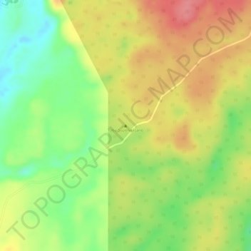
Name: Toba Supervolcano topographic map, elevation, terrain.
Location: Toba Supervolcano, Samosir, North Sumatra, Sumatra, Indonesia (2.57995 98.82995 2.58005 98.83005)
Average elevation: 1,563 m
Minimum elevation: 1,514 m
Maximum elevation: 1,604 m
Thank you for supporting this site ❤️
Make a donation
Make a donation
Other topographic maps
Click on a map to view its topography, its elevation and its terrain.