
Thank you for supporting this site ❤️
Make a donation
Make a donation
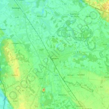
Geldern topographic map
Click on the map to display elevation.
Thank you for supporting this site ❤️
Make a donation
Make a donation
Geldern
Geldern lies in the plains of the lower, northern Rhineland, west of the Rhine. Its average elevation is 27 m AMSL. The river Niers, a tributary of the Meuse (Maas), flows through Geldern. The stream Gelderner Fleuth flows into the Niers in Geldern.
Thank you for supporting this site ❤️
Make a donation
Make a donation
About this map
Name: Geldern topographic map, elevation, terrain.
Location: Geldern, Kreis Kleve, North Rhine-Westphalia, 47608, Germany (51.46713 6.20062 51.57657 6.42059)
Average elevation: 28 m
Minimum elevation: 16 m
Maximum elevation: 54 m
Thank you for supporting this site ❤️
Make a donation
Make a donation
Other topographic maps
Click on a map to view its topography, its elevation and its terrain.
Thank you for supporting this site ❤️
Make a donation
Make a donation
An der Manier
Germany > North Rhine-Westphalia > Kreis Kleve > Kalkar > Neulouisendorf
Average elevation: 30 m
Thank you for supporting this site ❤️
Make a donation
Make a donation