
Mångån topographic map
Interactive map
Click on the map to display elevation.
About this map
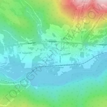
Name: Mångån topographic map, elevation, terrain.
Location: Mångån, Åre, Jämtland County, Region Norrland, 83015, Sweden (63.39274 12.91370 63.39284 12.91379)
Average elevation: 471 m
Minimum elevation: 376 m
Maximum elevation: 749 m
Other topographic maps
Click on a map to view its topography, its elevation and its terrain.
Åreskutan
Åreskutan, Åre, Jämtland County, Region Norrland, 83752, Sweden
Average elevation: 1,115 m
Helagsfjället
Helagsfjället, Berg, Jämtland County, Region Norrland, Sweden
Average elevation: 1,418 m
Åre
Sweden > Jämtland County > Åre
Åre, Jämtland County, Region Norrland, Sweden
Average elevation: 590 m
Tåsjöberget
Sweden > Jämtland County > Tåsjö District
Tåsjöberget, Tåsjö District, Strömsund, Province of Ångermanland, Jämtland County, Region Norrland, Sweden
Average elevation: 548 m