
Escondido topographic map
Interactive map
Click on the map to display elevation.
About this map
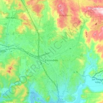
Name: Escondido topographic map, elevation, terrain.
Location: Escondido, San Diego County, California, United States (33.05766 -117.14612 33.21162 -116.99388)
Average elevation: 273 m
Minimum elevation: 87 m
Maximum elevation: 703 m
Escondido has a borderline semi-arid climate (Köppen: Bsh) and hot-summer Mediterranean climate (Köppen: Csa) with hot summers and cool wet winters. Owing to its inland setting it is considerably warmer than coastal cities like San Diego, Carlsbad or Oceanside during the summertime, and cooler in the winter. Yearly precipitation averages around 15 inches (380 mm) and can vary considerably from year to year. Rainfall totals are higher in the hills to the north and east, with 20-24 inches falling in most areas above 2,000 feet elevation, and over 30 inches on Palomar Mountain, 15 miles east. More than 80% of all precipitation takes place from November through March. Snow is virtually unheard of, though occasionally winter and springtime thunderstorms will drop small hail. The climate is mild enough to allow widespread cultivation of avocados and oranges. Escondido is located in a plant hardiness zone 10a. The hottest temperature recorded in Escondido was 115 °F on September 6, 2020. The coldest temperature recorded in Escondido was 13 °F on January 2, 1901, and January 7, 1913.[16]
Other topographic maps
Click on a map to view its topography, its elevation and its terrain.
Bonsall
United States > California > San Diego County
Bonsall, San Diego County, California, 92003, United States
Average elevation: 98 m
San Marcos
United States > California > San Diego County
San Marcos, San Diego County, California, United States
Average elevation: 225 m
Chula Vista
United States > California > San Diego County
Chula Vista, San Diego County, California, United States
Average elevation: 43 m
Potrero
United States > California > San Diego County > Potrero
Potrero, San Diego County, California, 91963, United States
Average elevation: 715 m