
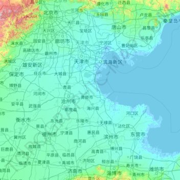
Tianjin topographic map
Interactive map
Click on the map to display elevation.
About this map
Name: Tianjin topographic map, elevation, terrain.
Location: Tianjin, China (36.56626 113.72998 40.25201 118.05867)
Average elevation: 64 m
Minimum elevation: -4 m
Maximum elevation: 2,561 m
There is 153 km (95 mi) of coastline and 1,137.48 kilometers (706.80 mi) of land border. It lies at the northern end of the Grand Canal of China, which connects with the Yellow River and Yangtze River. The municipality is generally flat, and swampy near the coast, but hilly in the far north, where the Yan Mountains intrude into northern Tianjin. Extensive tidal flats occur on the coastal plain adjacent to the city. The highest point in the municipality is Jiuding Peak (九顶山) in Ji County on the northern border with Hebei, at an altitude of 1,078.5 m (3,538 ft).
Other topographic maps
Click on a map to view its topography, its elevation and its terrain.
Guanxian County
Guanxian County, Liaocheng, Shandong, 252500, China
Average elevation: 41 m
Islands District
Islands District, New Territories, Hong Kong, China
Average elevation: 36 m
Double Island
China > Hong Kong > North District > Tung Wan
Double Island, Tung Wan, North District, New Territories, Hong Kong, China
Average elevation: 12 m
Lanting
China > Jiangxi > Hukou County > Junqiao
Lanting, Junqiao, Hukou County, Jiangxi, China
Average elevation: 23 m
Labo River
China > Sichuan > Litang County > Nabo > Zhazha
Labo River, Zhazha, Nabo, Litang County, Kardze, Sichuan, China
Average elevation: 3,708 m
Fenghuang Mountain
China > Zhejiang > Hangzhou City
Fenghuang Mountain, Hangzhou City, Zhejiang, 310002, China
Average elevation: 44 m
Fenghuang County
Fenghuang County, Xiangxi, Hunan, 416200, China
Average elevation: 497 m
Bao'an District
Bao'an District, Shenzhen, Guangdong Province, 518100, China
Average elevation: 36 m
Kashgar Prefecture
China > Xinjiang > Kashgar City
Kashgar Prefecture, Kashgar City, Kachgar, Xinjiang, 844000, China
Average elevation: 2,275 m
Lian River
China > Jiangxi > Yudu County
Lian River, Yudu County, Ganzhou, Jiangxi, China
Average elevation: 243 m
Golog Tibetan Autonomous Prefecture
China > Qinghai > Gadê County
Golog Tibetan Autonomous Prefecture, Gadê County, Golog, Qinghai, China
Average elevation: 4,340 m
Heihe
China > Heilongjiang > 幸福乡
Heihe, 幸福乡, Aihui District, Heihe City, Heilongjiang, 164300, China
Average elevation: 174 m
Mudanjiang
Mudanjiang, Revitalize the streets, Dong'an District, Mudanjiang City, Heilongjiang, 157000, China
Average elevation: 361 m
Shui Choi Tin Village
China > Hong Kong > Hong Kong Island
Shui Choi Tin Village, Southern District, Hong Kong Island, Hong Kong, China
Average elevation: 94 m
Baotou City
Baotou City, Inner Mongolia, 014000, China
Average elevation: 1,318 m
Chengguan District
Chengguan District, Lhasa, Tibet, 850000, China
Average elevation: 4,325 m