
Western topographic map
Interactive map
Click on the map to display elevation.
About this map
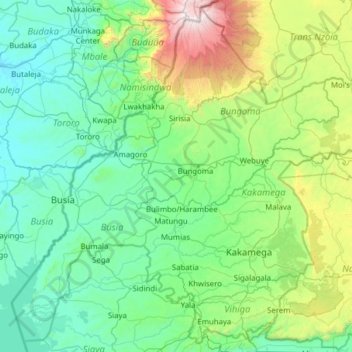
Name: Western topographic map, elevation, terrain.
Location: Western, Kenya (-0.04054 33.90969 1.14486 35.15589)
Average elevation: 1,537 m
Minimum elevation: 1,056 m
Maximum elevation: 4,263 m
Other topographic maps
Click on a map to view its topography, its elevation and its terrain.
Dabel
Kenya > Marsabit County > Moyale > Golobo ward
Dabel, Golobo ward, Moyale, Marsabit County, Eastern, Kenya
Average elevation: 654 m
Ewuaso Oonkidong'i ward
Ewuaso Oonkidong'i ward, Kajiado West, Rift Valley, Kenya
Average elevation: 1,580 m
Nanyuki
Kenya > Laikipia County > Laikipia East
Nanyuki, Laikipia East, Laikipia County, Rift Valley, Kenya
Average elevation: 1,937 m
Nairobi
Kenya > Nairobi County > Starehe
Nairobi, Starehe, Nairobi County, Nairobi, Kenya
Average elevation: 1,729 m
Chesoi
Kenya > Elgeyo-Marakwet County > Marakwet West
Chesoi, Marakwet West, Elgeyo-Marakwet County, Rift Valley, Kenya
Average elevation: 1,958 m
Nyeri
Kenya > Nyeri > Nyeri Central
Nyeri, Nyeri Central, Nyeri, Central Kenya, Kenya
Average elevation: 1,796 m
Lake Turkana
Lake Turkana, Marsabit County, Eastern, Kenya
Average elevation: 590 m