
Granite County topographic map
Interactive map
Click on the map to display elevation.
About this map
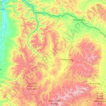
Name: Granite County topographic map, elevation, terrain.
Location: Granite County, Montana, United States (45.93863 -113.87836 46.83380 -113.03153)
Average elevation: 1,800 m
Minimum elevation: 951 m
Maximum elevation: 3,216 m
Other topographic maps
Click on a map to view its topography, its elevation and its terrain.
Pablo
United States > Montana > Lake County > Pablo
Pablo, Lake County, Montana, 59855, United States
Average elevation: 946 m
West Glacier
United States > Montana > West Glacier
West Glacier, Flathead County, Montana, 59936, United States
Average elevation: 1,201 m
Cascade County
Cascade County, Montana, United States
Average elevation: 1,370 m
Big Horn County
Big Horn County, Montana, United States
Average elevation: 1,220 m