
Mölln topographic map
Interactive map
Click on the map to display elevation.
About this map
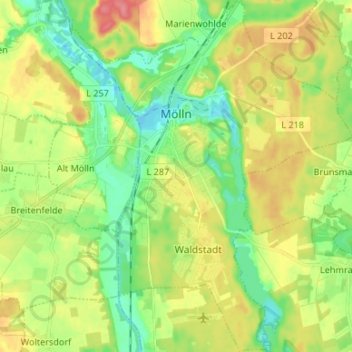
Name: Mölln topographic map, elevation, terrain.
Average elevation: 37 m
Minimum elevation: 8 m
Maximum elevation: 78 m
Other topographic maps
Click on a map to view its topography, its elevation and its terrain.
Mölln
Duitsland > Sleeswijk-Holstein > Herzogtum Lauenburg > Mölln > Mölln
Mölln, Herzogtum Lauenburg, Sleeswijk-Holstein, 23879, Duitsland
Average elevation: 37 m
Lauenburg/Elbe
Duitsland > Sleeswijk-Holstein > Herzogtum Lauenburg > Lauenburg/Elbe
Lauenburg/Elbe, Herzogtum Lauenburg, Sleeswijk-Holstein, 21481, Duitsland
Average elevation: 21 m
Woltersdorf
Duitsland > Sleeswijk-Holstein > Herzogtum Lauenburg > Woltersdorf
Woltersdorf, Breitenfelde, Herzogtum Lauenburg, Sleeswijk-Holstein, Duitsland
Average elevation: 41 m