
Tillamook County topographic map
Interactive map
Click on the map to display elevation.
About this map
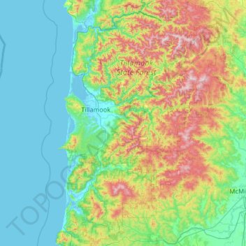
Name: Tillamook County topographic map, elevation, terrain.
Location: Tillamook County, Oregon, United States of America (45.04442 -124.09575 45.78360 -123.29927)
Average elevation: 236 m
Minimum elevation: -3 m
Maximum elevation: 1,073 m
According to the U.S. Census Bureau, the county has a total area of 1,333 square miles (3,450 km2), of which 1,103 square miles (2,860 km2) is land and 230 square miles (600 km2) (17%) is water. At 3,706 feet (1130 m) in elevation, Rogers Peak is the highest point in the county and the highest in the Northern Oregon Coast Range.
Other topographic maps
Click on a map to view its topography, its elevation and its terrain.
Lane County
United States of America > Oregon
Lane County, Oregon, United States of America
Average elevation: 712 m
Multnomah County
United States of America > Oregon
Multnomah County, Oregon, United States of America
Average elevation: 334 m
Klamath County
United States of America > Oregon
Klamath County, Oregon, United States of America
Average elevation: 1,420 m
Clackamas County
United States of America > Oregon
Clackamas County, Oregon, United States of America
Average elevation: 660 m