
Vatovavy-Fitovinany topographic map
Interactive map
Click on the map to display elevation.
About this map
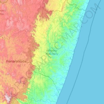
Name: Vatovavy-Fitovinany topographic map, elevation, terrain.
Location: Vatovavy-Fitovinany, Province de Fianarantsoa, Madagascar (-22.32047 47.06403 -20.21155 48.59849)
Average elevation: 525 m
Minimum elevation: -2 m
Maximum elevation: 2,571 m
Other topographic maps
Click on a map to view its topography, its elevation and its terrain.
Ampasimandroro
Madagascar > Vatovavy-Fitovinany > Ampasimandroro
Ampasimandroro, Vatovavy-Fitovinany, Province de Fianarantsoa, 316, Madagascar
Average elevation: 1 m