
Marikina River topographic map
Interactive map
Click on the map to display elevation.
About this map
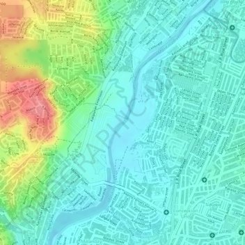
Name: Marikina River topographic map, elevation, terrain.
Location: Marikina River, Marikina, Metro Manila, 1808, Philippines (14.66290 121.09719 14.66374 121.09792)
Average elevation: 29 m
Minimum elevation: 2 m
Maximum elevation: 96 m
Other topographic maps
Click on a map to view its topography, its elevation and its terrain.
Marikina River
The river's depth ranges from 3 to 21 metres (9.8 to 68.9 ft) and spans from 70 to 120 metres (230 to 390 ft). It has a total area of nearly 75.2 hectares (0.752 km2) and is 27 kilometres (17 mi) long. The riverbank has an elevation of 8 meters above sea level at the boundary of San Mateo and Marikina. This…
Average elevation: 66 m