
Baybay topographic map
Interactive map
Click on the map to display elevation.
About this map
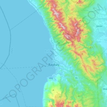
Name: Baybay topographic map, elevation, terrain.
Average elevation: 157 m
Minimum elevation: 0 m
Maximum elevation: 1,137 m
The climate is of Coronas Climate type IV, which is generally wet with no particularly discernible seasons. Its topography is generally mountainous in the eastern portion as it slopes down west towards the shore line. Generally an agricultural city, the common means of livelihood are farming and fishing. Some are engaged in hunting and in forestal activities. The most common crops grown are rice, corn, abaca, root crops, fruits, and vegetables. Various cottage industries can also be found in Baybay such as bamboo and rattan craft, ceramics, dress-making, fiber craft, food preservation, mat weaving, metal craft, furniture manufacture and other related activities.
Other topographic maps
Click on a map to view its topography, its elevation and its terrain.
Tacloban
Philippines > Leyte > Tacloban
Tacloban, Leyte, Eastern Visayas, 6500, Philippines
Average elevation: 29 m
Campina
Philippines > Leyte > Hilongos
Campina, Hilongos, 5th District, Leyte, Eastern Visayas, 6524, Philippines
Average elevation: 10 m
Ormoc
Philippines > Leyte > Ormoc
Ormoc, Leyte 4th District, Leyte, Eastern Visayas, 6541, Philippines
Average elevation: 204 m
Salvacion
Philippines > Leyte > Ormoc
Salvacion, Ormoc, 4th District, Leyte, Eastern Visayas, 6541, Philippines
Average elevation: 41 m
Bunga
Philippines > Leyte > Abuyog
Bunga, Abuyog, 5th District, Leyte, Eastern Visayas, 6510, Philippines
Average elevation: 4 m
Mt. Mahagnao
Philippines > Leyte > Burauen
Mt. Mahagnao, Burauen, 2nd District, Leyte, Eastern Visayas, 6516, Philippines
Average elevation: 567 m
Cabintan
Philippines > Leyte > Ormoc
Cabintan, Ormoc, 4th District, Leyte, Eastern Visayas, 6541, Philippines
Average elevation: 689 m
Himokilan Island
Philippines > Leyte > Hindang
Himokilan Island, Hindang, 5th District, Leyte, Eastern Visayas, 6523, Philippines
Average elevation: 1 m
Canfabi
Philippines > Leyte > Carigara
Canfabi, Carigara, 2nd District, Leyte, Eastern Visayas, 6529, Philippines
Average elevation: 42 m
Digyo
Philippines > Leyte > Inopacan > Apid
Digyo, Apid, Inopacan, 5th District, Leyte, Eastern Visayas, 6522, Philippines
Average elevation: 0 m
Patag
Philippines > Leyte > Baybay
Patag, Baybay, 5th District, Leyte, Eastern Visayas, 6521, Philippines
Average elevation: 64 m
Gimarco
Philippines > Leyte > Leyte
Gimarco, Leyte, 3rd District, Leyte, Eastern Visayas, 6533, Philippines
Average elevation: 38 m
Tagpuro
Philippines > Leyte > Tacloban
Tagpuro, Tacloban, Leyte, Eastern Visayas, Philippines
Average elevation: 12 m
Lonoy
Philippines > Leyte > Kananga
Lonoy, Kananga, 2nd District, Leyte, Eastern Visayas, Philippines
Average elevation: 121 m
Children's Park
Philippines > Leyte > Hilongos > Atabay
Children's Park, Atabay, Hilongos, 5th District, Leyte, Eastern Visayas, 6524, Philippines
Average elevation: 3 m
Cantariwis
Philippines > Leyte > Tolosa
Cantariwis, Tolosa, 1st District, Leyte, Eastern Visayas, 6503, Philippines
Average elevation: 6 m
Katipunan
Philippines > Leyte > Bato
Katipunan, Bato, 5th District, Leyte, Eastern Visayas, 6604, Philippines
Average elevation: 167 m
Mahayahay
Philippines > Leyte > Ormoc
Mahayahay, Ormoc, 4th District, Leyte, Eastern Visayas, Philippines
Average elevation: 169 m
Tombo
Philippines > Leyte > Alangalang
Tombo, Alangalang, 1st District, Leyte, Eastern Visayas, 6517, Philippines
Average elevation: 51 m
Palhi
Philippines > Leyte > Baybay
Palhi, Baybay, 5th District, Leyte, Eastern Visayas, 6521, Philippines
Average elevation: 20 m
Dawahon
Philippines > Leyte > Bato
Dawahon, Bato, 5th District, Leyte, Eastern Visayas, 6525, Philippines
Average elevation: 0 m
Tabontabon
Tabontabon, 2nd District, Leyte, Eastern Visayas, 6504, Philippines
Average elevation: 16 m
Lake
Philippines > Leyte > Hilongos > Atabay
Lake, Atabay, Hilongos, Leyte 5th District, Leyte, Eastern Visayas, 6524, Philippines
Average elevation: 2 m
Baybay
Philippines > Leyte > Baybay
Baybay, Leyte 5th District, Leyte, Eastern Visayas, 6521, Philippines
Average elevation: 163 m
Hampipila
Philippines > Leyte > Abuyog
Hampipila, Abuyog, Leyte 5th District, Leyte, Eastern Visayas, Philippines
Average elevation: 37 m
Pawing
Philippines > Leyte > Palo
Pawing, Palo, Leyte 1st District, Leyte, Eastern Visayas, 6501, Philippines
Average elevation: 10 m
Danao
Philippines > Leyte > Ormoc
Danao, Ormoc, Leyte 4th District, Leyte, Eastern Visayas, 6541, Philippines
Average elevation: 704 m
Cristina
Philippines > Leyte > Calubian
Cristina, Calubian, Leyte 3rd District, Leyte, Eastern Visayas, 6534, Philippines
Average elevation: 69 m
Salog River
Philippines > Leyte > Hilongos
Salog River, Hilongos, Leyte 5th District, Leyte, Eastern Visayas, 6524, Philippines
Average elevation: 91 m
Tambulilid
Philippines > Leyte > Ormoc
Tambulilid, Ormoc, Leyte 4th District, Leyte, Eastern Visayas, 6541, Philippines
Average elevation: 8 m
San Miguel
Philippines > Leyte > Tanauan > SOS Village Pago
San Miguel, SOS Village Pago, Tanauan, Leyte 1st District, Leyte, Eastern Visayas, 6502, Philippines
Average elevation: 6 m
Tinaguban
Philippines > Leyte > Carigara
Tinaguban, Carigara, Leyte 2nd District, Leyte, Eastern Visayas, 6529, Philippines
Average elevation: 174 m
Mabuhay
Philippines > Leyte > Mahaplag
Mabuhay, Mahaplag, Leyte 5th District, Leyte, Eastern Visayas, 6512, Philippines
Average elevation: 105 m
Sante Fe
Philippines > Leyte > Matalom
Sante Fe, Matalom, Leyte 5th District, Leyte, Eastern Visayas, 6526, Philippines
Average elevation: 26 m
Palo
Philippines > Leyte > Palo
Palo, Leyte 1st District, Leyte, Eastern Visayas, 6501, Philippines
Average elevation: 11 m
Telegrafo
Philippines > Leyte > Tolosa
Telegrafo, Tolosa, Leyte 1st District, Leyte, Eastern Visayas, 6503, Philippines
Average elevation: 17 m
Salog
Philippines > Leyte > Leyte
Salog, Leyte, Leyte 3rd District, Leyte, Eastern Visayas, 6533, Philippines
Average elevation: 24 m
San Isidro
Philippines > Leyte > Jaro
San Isidro, Jaro, Leyte 2nd District, Leyte, Eastern Visayas, 6527, Philippines
Average elevation: 57 m
Poblacion Zone 1
Philippines > Leyte > Javier
Poblacion Zone 1, Javier, Leyte 5th District, Leyte, Eastern Visayas, 6511, Philippines
Average elevation: 31 m
Palompon
Philippines > Leyte > Palompon
Palompon, Leyte 4th District, Leyte, Eastern Visayas, 6538, Philippines
Average elevation: 14 m
Lower Utod (Guadalupe)
Philippines > Leyte > Baybay
Lower Utod (Guadalupe), Baybay, Leyte 5th District, Leyte, Eastern Visayas, 6521, Philippines
Average elevation: 29 m
Pagbanganan River
Philippines > Leyte > Baybay > Kantagnos
Pagbanganan River, Kantagnos, Baybay, Leyte 5th District, Leyte, Eastern Visayas, 6521, Philippines
Average elevation: 145 m
Liberacion
Philippines > Leyte > Mahaplag
Liberacion, Mahaplag, Leyte 5th District, Leyte, Eastern Visayas, 6512, Philippines
Average elevation: 201 m
Abuyog
Philippines > Leyte > Abuyog
Abuyog, Leyte 5th District, Leyte, Eastern Visayas, 6510, Philippines
Average elevation: 11 m
Babatngon
Philippines > Leyte > Babatngon
Babatngon, Leyte, Eastern Visayas, 6520, Philippines
Average elevation: 36 m
Mahaplag
Philippines > Leyte > Mahaplag
Mahaplag, Leyte 5th District, Leyte, Eastern Visayas, 6512, Philippines
Average elevation: 240 m
o
Philippines > Leyte > Tanauan
o, Tanauan, Leyte 1st District, Leyte, Eastern Visayas, 6502, Philippines
Average elevation: 7 m
Abuyog
Abuyog, 5th District, Leyte, Eastern Visayas, 6510, Philippines
Average elevation: 188 m
Alangalang
Philippines > Leyte > Alangalang
Alangalang, Leyte 1st District, Leyte, Eastern Visayas, 6517, Philippines
Average elevation: 36 m