
Laurel Island topographic map
Interactive map
Click on the map to display elevation.
About this map
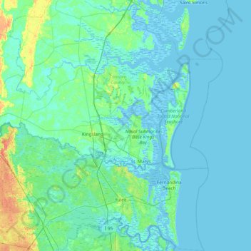
Name: Laurel Island topographic map, elevation, terrain.
Location: Laurel Island, Camden County, Georgia, 31547, USA (30.50079 -81.91093 31.14079 -81.27093)
Average elevation: 4 m
Minimum elevation: -3 m
Maximum elevation: 35 m
Other topographic maps
Click on a map to view its topography, its elevation and its terrain.
Ferrell Crossroads
USA > Georgia > Ferrell Crossroads
Ferrell Crossroads, Early County, Georgia, USA
Average elevation: 94 m
Cameron Point
USA > Georgia > Cameron Point
Cameron Point, Hall County, Georgia, 30506:30534, USA
Average elevation: 339 m