
Tambler topographic map
Interactive map
Click on the map to display elevation.
About this map
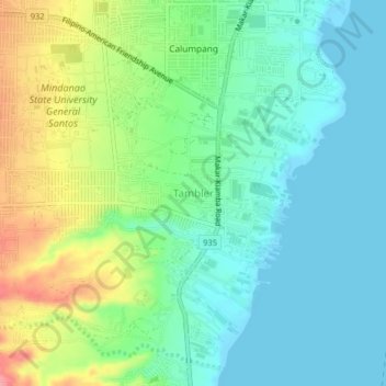
Name: Tambler topographic map, elevation, terrain.
Location: Tambler, General Santos, Philippines (6.03791 125.12046 6.07791 125.16046)
Average elevation: 31 m
Minimum elevation: -2 m
Maximum elevation: 101 m
Other topographic maps
Click on a map to view its topography, its elevation and its terrain.
Sinawal
Sinawal, General Santos, Soccsksargen, 9500, Philippines
Average elevation: 145 m
Paopao
Paopao, General Santos, Soccsksargen, 9500, Philippines
Average elevation: 515 m
Fatima
Fatima, General Santos, Soccsksargen, Philippines
Average elevation: 98 m
Barangay Buayan Park
Philippines > General Santos > Maligaya
Barangay Buayan Park, Maligaya, General Santos, Soccsksargen, Philippines
Average elevation: 7 m
Conel
Conel, General Santos, Soccsksargen, Philippines
Average elevation: 105 m