
Mayne Island topographic map
Interactive map
Click on the map to display elevation.
About this map
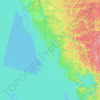
Name: Mayne Island topographic map, elevation, terrain.
Average elevation: 194 m
Minimum elevation: 172 m
Maximum elevation: 277 m
Other topographic maps
Click on a map to view its topography, its elevation and its terrain.
Freedom Island
Canada > Ontario > The Archipelago
Freedom Island, The Archipelago, Parry Sound District, Ontario, Canada
Average elevation: 201 m
Isabel Island
Canada > Ontario > The Archipelago
Isabel Island, The Archipelago, Parry Sound District, Ontario, Canada
Average elevation: 198 m
Range Island
Canada > Ontario > The Archipelago
Range Island, The Archipelago, Parry Sound District, Ontario, Canada
Average elevation: 196 m
Gay Island
Canada > Ontario > The Archipelago
Gay Island, The Archipelago, Parry Sound District, Ontario, Canada
Average elevation: 196 m