
Derbyshire topographic map
Interactive map
Click on the map to display elevation.
About this map
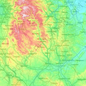
Name: Derbyshire topographic map, elevation, terrain.
Average elevation: 144 m
Minimum elevation: 0 m
Maximum elevation: 637 m
Other topographic maps
Click on a map to view its topography, its elevation and its terrain.
Burton-on-Trent
United Kingdom > England > East Staffordshire > Burton-on-Trent
Burton-on-Trent, East Staffordshire, Staffordshire, England, DE14 1JN, United Kingdom
Average elevation: 69 m
Denstone
United Kingdom > England > East Staffordshire > Denstone
Denstone, East Staffordshire, Staffordshire, West Midlands, England, ST14 5GB, United Kingdom
Average elevation: 118 m