
Lahul and Spiti topographic map
Interactive map
Click on the map to display elevation.
About this map
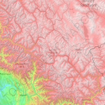
Name: Lahul and Spiti topographic map, elevation, terrain.
Location: Lahul and Spiti, Himachal Pradesh, India (31.75233 76.37130 33.25567 78.69266)
Average elevation: 4,286 m
Minimum elevation: 519 m
Maximum elevation: 6,643 m
The two valleys are quite different in character. Spiti is more barren and difficult to cross, with an average elevation of the valley floor of 4,270 m (14,010 ft). It is enclosed between lofty ranges, with the Spiti river rushing out of a gorge in the southeast to meet the Sutlej River. It is a typical mountain desert area with an average annual rainfall of only 170 mm (6.7 in).
Other topographic maps
Click on a map to view its topography, its elevation and its terrain.
Palampur
Palampur, Kangra District, Himachal Pradesh, India
Average elevation: 1,520 m
Talkehr
India > Himachal Pradesh > Jogindarnagar > Ahju
Talkehr, Ahju, Jogindarnagar, Mandi District, Himachal Pradesh, 176077, India
Average elevation: 1,337 m
Pulag
India > Himachal Pradesh > Kullu > Barehigran
Pulag, Barehigran, Kullu, Kullu District, Himachal Pradesh, 175130, India
Average elevation: 2,494 m
Kullu
India > Himachal Pradesh > Kullu
Kullu, Himachal Pradesh, 175100, India
Average elevation: 1,808 m
Waknaghat
India > Himachal Pradesh > Waknaghat
Waknaghat, Solan, Himachal Pradesh, India
Average elevation: 1,557 m