
Washburn County topographic map
Interactive map
Click on the map to display elevation.
About this map
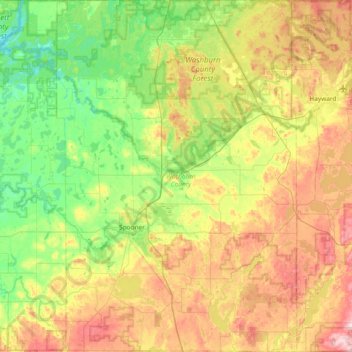
Name: Washburn County topographic map, elevation, terrain.
Location: Washburn County, Wisconsin, USA (45.63776 -92.05103 46.15770 -91.54010)
Average elevation: 358 m
Minimum elevation: 274 m
Maximum elevation: 504 m
Other topographic maps
Click on a map to view its topography, its elevation and its terrain.
Burnham Park
Burnham Park, Milwaukee, Milwaukee County, Wisconsin, USA
Average elevation: 201 m
James Madison Park
James Madison Park, Madison, Dane County, Wisconsin, USA
Average elevation: 263 m
Anchor Island
Anchor Island, Town of Oma, Iron County, Wisconsin, USA
Average elevation: 462 m
Adams Beach
USA > Wisconsin > Adams Beach
Adams Beach, Town of Belle Plaine, Shawano County, Wisconsin, 54933, USA
Average elevation: 249 m