
Cabilao Island topographic map
Interactive map
Click on the map to display elevation.
About this map
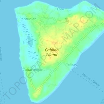
Name: Cabilao Island topographic map, elevation, terrain.
Average elevation: 6 m
Minimum elevation: -1 m
Maximum elevation: 24 m
Other topographic maps
Click on a map to view its topography, its elevation and its terrain.
Loboc River
Philippines > Bohol > Tagbilaran
Loboc River, Tagbilaran, Bohol, Central Visayas, Philippines
Average elevation: 199 m
Loboc River
Philippines > Bohol > Tagbilaran
Loboc River, Tagbilaran, Bohol, Central Visayas, 6316, Philippines
Average elevation: 28 m
Cancostino Island
Philippines > Bohol > Tagbilaran
Cancostino Island, Tagbilaran, Bohol, Central Visayas, 6329, Philippines
Average elevation: 89 m
Cabgan Islet
Philippines > Bohol > Tagbilaran
Cabgan Islet, Tagbilaran, Bohol, Central Visayas, 6329, Philippines
Average elevation: 90 m
Catang Island
Philippines > Bohol > Tagbilaran
Catang Island, Tagbilaran, Bohol, Central Visayas, Philippines
Average elevation: 79 m
Mantatao Island
Philippines > Bohol > Tagbilaran
Mantatao Island, Tagbilaran, Bohol, Central Visayas, Philippines
Average elevation: 0 m
Silo Island
Philippines > Bohol > Tagbilaran
Silo Island, Tagbilaran, Bohol, Central Visayas, 6330, Philippines
Average elevation: 90 m
Sandingan Island
Philippines > Bohol > Tagbilaran
Sandingan Island, Tagbilaran, Bohol, Central Visayas, Philippines
Average elevation: 10 m