
Aviernoz topographic map
Interactive map
Click on the map to display elevation.
About this map
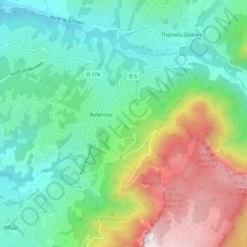
Name: Aviernoz topographic map, elevation, terrain.
Average elevation: 938 m
Minimum elevation: 546 m
Maximum elevation: 1,826 m
Other topographic maps
Click on a map to view its topography, its elevation and its terrain.
Place de la Mairie
France > Auvergne-Rhône-Alpes > Fillière
Place de la Mairie, Thorens-Glières, Fillière, Annecy, Upper Savoy, Auvergne-Rhône-Alpes, Metropolitan France, 74570, France
Average elevation: 731 m