
Ovalle topographic map
Interactive map
Click on the map to display elevation.
About this map
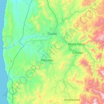
Name: Ovalle topographic map, elevation, terrain.
Location: Ovalle, Provincia de Limarí, Región de Coquimbo, Chile (-31.21679 -71.71685 -30.31047 -70.85255)
Average elevation: 765 m
Minimum elevation: 0 m
Maximum elevation: 3,718 m
Other topographic maps
Click on a map to view its topography, its elevation and its terrain.
Parque Nacional Bosque de Fray Jorge
Chile > Región de Coquimbo > Ovalle
Parque Nacional Bosque de Fray Jorge, Cruce Longitudinal (Cerrillos Pobres) - Fray Jorge, Ovalle, Provincia de Limarí, Región de Coquimbo, Chile
Average elevation: 172 m