
Obra topographic map
Interactive map
Click on the map to display elevation.
About this map
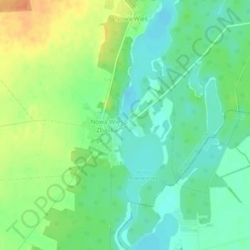
Name: Obra topographic map, elevation, terrain.
Average elevation: 63 m
Minimum elevation: 47 m
Maximum elevation: 88 m
Other topographic maps
Click on a map to view its topography, its elevation and its terrain.
Piła County
Poland > Greater Poland Voivodeship
Piła County, Greater Poland Voivodeship, Poland
Average elevation: 99 m
Koźmin Wielkopolski
Poland > Greater Poland Voivodeship > Krotoszyn County
Koźmin Wielkopolski, gmina Koźmin Wielkopolski, Krotoszyn County, Greater Poland Voivodeship, Poland
Average elevation: 139 m
Środa Wielkopolska
Poland > Greater Poland Voivodeship > Środa Wielkopolska County
Środa Wielkopolska, gmina Środa Wielkopolska, Środa Wielkopolska County, Greater Poland Voivodeship, 63-000, Poland
Average elevation: 86 m
Pila
Poland > Greater Poland Voivodeship > Piła County
Pila, Piła County, Greater Poland Voivodeship, 64-920, Poland
Average elevation: 78 m
Kostrzyn
Poland > Greater Poland Voivodeship > Kostrzyn
Kostrzyn, gmina Kostrzyn, powiat poznański, Greater Poland Voivodeship, 62-025, Poland
Average elevation: 100 m