
Toulon topographic map
Interactive map
Click on the map to display elevation.
About this map
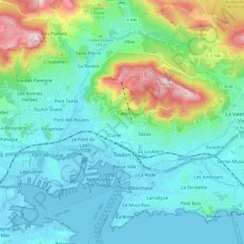
Name: Toulon topographic map, elevation, terrain.
Average elevation: 132 m
Minimum elevation: -3 m
Maximum elevation: 574 m
Other topographic maps
Click on a map to view its topography, its elevation and its terrain.
Saint-Raphaël
France > Provence-Alpes-Côte d'Azur > Var
Saint-Raphaël, Draguignan, Var, Provence-Alpes-Côte d'Azur, Metropolitan France, France
Average elevation: 88 m