
Toulouse topographic map
Interactive map
Click on the map to display elevation.
About this map
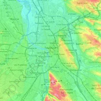
Name: Toulouse topographic map, elevation, terrain.
Location: Toulouse, Haute-Garonne, Occitania, Metropolitan France, France (43.53265 1.35040 43.66871 1.51538)
Average elevation: 155 m
Minimum elevation: 117 m
Maximum elevation: 262 m
The first half of the 14th century was a prosperous period, despite the dismemberment in 1317 of the very large bishopric of Toulouse (which lost two thirds of its area and a large part of its income, a loss only partially compensated by its elevation to the rank of archbishopric), and the episode of the Shepherds' Crusade which brought a pogrom against Toulouse's Jewish population in 1320. In 1335, Toulouse had between 35,000 and 40,000 inhabitants.