
Rennes topographic map
Interactive map
Click on the map to display elevation.
About this map
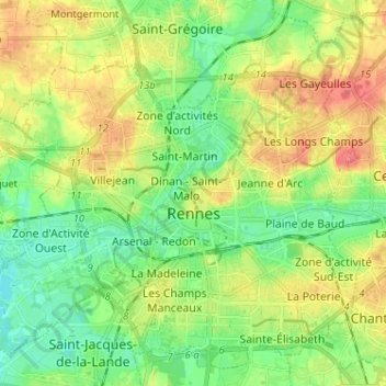
Name: Rennes topographic map, elevation, terrain.
Location: Rennes, Ille-et-Vilaine, Brittany, Metropolitan France, France (48.07692 -1.75259 48.15497 -1.62440)
Average elevation: 42 m
Minimum elevation: 17 m
Maximum elevation: 78 m
Other topographic maps
Click on a map to view its topography, its elevation and its terrain.
Bais
France > Brittany > Ille-et-Vilaine
Bais, Fougères-Vitré, Ille-et-Vilaine, Brittany, Metropolitan France, 35680, France
Average elevation: 79 m