
Grant County topographic map
Interactive map
Click on the map to display elevation.
About this map
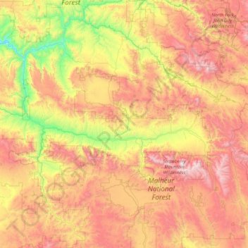
Name: Grant County topographic map, elevation, terrain.
Location: Grant County, Oregon, United States (43.95742 -119.67199 44.99817 -118.22349)
Average elevation: 1,425 m
Minimum elevation: 537 m
Maximum elevation: 2,660 m
The elevation of the county varies from 1,820 on the John Day River near Kimberly, to 9,038 feet (2,755 m) at the summit of Strawberry Mountain. The terrain of the county varies from grassland steppes and rangelands in relatively open or rolling hills and valleys, to steep, rugged, rocky high-alpine landscapes. Between these, the county contains heavily timbered land, many rolling hills, canyons and mountainous terrain. Portions of the county are technically high desert, dominated by sagebrush and sparse grasses.
Other topographic maps
Click on a map to view its topography, its elevation and its terrain.
Sandy
United States > Oregon > Clackamas County
Sandy, Clackamas County, Oregon, 97055, United States
Average elevation: 247 m
Portland
United States > Oregon > Multnomah County
Portland, Multnomah County, Oregon, United States
Average elevation: 77 m
Oregon City
United States > Oregon > Clackamas County
Oregon City, Clackamas County, Oregon, 97045, United States
Average elevation: 99 m
Bend
United States > Oregon > Deschutes County
Bend, Deschutes County, Oregon, United States
Average elevation: 1,121 m
Ashland
United States > Oregon > Jackson County
Ashland, Jackson County, Oregon, United States
Average elevation: 774 m
Eugene
United States > Oregon > Lane County
Eugene, Lane County, Oregon, United States
Average elevation: 163 m
Hillsboro
United States > Oregon > Washington County
Hillsboro, Washington County, Oregon, United States
Average elevation: 53 m
Deschutes County
Deschutes County, Oregon, United States
Average elevation: 1,324 m
Hood River County
Hood River County, Oregon, United States
Average elevation: 860 m
Mount Mazama
United States > Oregon > Klamath County
Mount Mazama, Klamath County, Oregon, United States
Average elevation: 1,880 m