
Klingenthal topographic map
Interactive map
Click on the map to display elevation.
About this map
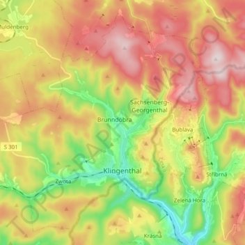
Name: Klingenthal topographic map, elevation, terrain.
Location: Klingenthal, Vogtlandkreis, Saksen, Duitsland (50.33373 12.36468 50.42047 12.51679)
Average elevation: 734 m
Minimum elevation: 516 m
Maximum elevation: 958 m
Other topographic maps
Click on a map to view its topography, its elevation and its terrain.
Reuth
Duitsland > Saksen > Vogtlandkreis > Schönlind
Reuth, Schönlind, Weischlitz, Vogtlandkreis, Saksen, 08538, Duitsland
Average elevation: 520 m
Leubnitz
Duitsland > Saksen > Vogtlandkreis > Leubnitz
Leubnitz, Rosenbach/Vogtland, Vogtlandkreis, Saksen, 08539, Duitsland
Average elevation: 459 m
Plauen
Duitsland > Saksen > Vogtlandkreis
Plauen, Vogtlandkreis, Saksen, Duitsland
Average elevation: 429 m