
The Bronx topographic map
Interactive map
Click on the map to display elevation.
About this map
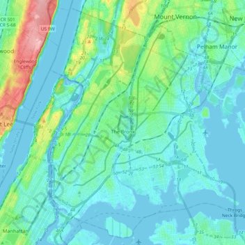
Name: The Bronx topographic map, elevation, terrain.
Location: The Bronx, New York, United States (40.78574 -73.93391 40.91763 -73.74837)
Average elevation: 23 m
Minimum elevation: -9 m
Maximum elevation: 139 m
Other topographic maps
Click on a map to view its topography, its elevation and its terrain.
New York County
United States > New York > New York
New York County, New York, United States
Average elevation: 16 m
Queens County
United States > New York > New York
Queens County, New York, United States
Average elevation: 11 m
Kings County
United States > New York > New York
Kings County, New York, United States
Average elevation: 9 m