
Mount Uling topographic map
Interactive map
Click on the map to display elevation.
About this map
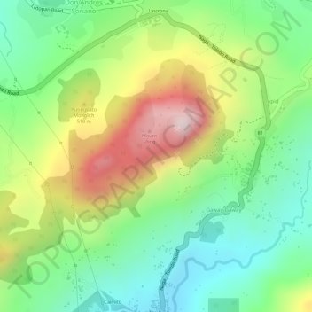
Name: Mount Uling topographic map, elevation, terrain.
Location: Mount Uling, Naga, Cebu, Central Visayas, Philippines (10.29467 123.71245 10.29477 123.71255)
Average elevation: 333 m
Minimum elevation: 135 m
Maximum elevation: 613 m
Other topographic maps
Click on a map to view its topography, its elevation and its terrain.
Naga River
Philippines > Cebu > Naga
Naga River, Naga, Cebu, Central Visayas, Philippines
Average elevation: 253 m
Pangdan
Philippines > Cebu > Naga > Pangdan
Pangdan, Naga, Cebu, Central Visayas, 86017, Philippines
Average elevation: 139 m