
Make a donation
Chennai topographic map
Click on the map to display elevation.
Make a donation
Chennai
Chennai is located on the southeastern coast of India in the northeastern part of Tamil Nadu on a flat coastal plain known as the Eastern Coastal Plains with an average elevation of 6.7 m (22 ft) and highest point at 60 m (200 ft). Chennai's soil is mostly clay, shale and sandstone. Clay underlies most of the city with sandy areas found along the river banks and coasts where rainwater runoff percolates quickly through the soil. Certain areas in South Chennai have a hard rock surface. As of 2018, the city had a green cover of 14.9 per cent, with a per capita green cover of 8.5 square metres against the World Health Organization recommendation of nine square metres.
Make a donation
About this map
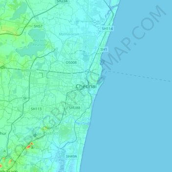
Name: Chennai topographic map, elevation, terrain.
Location: Chennai, Tamil Nadu, 600001, India (12.92369 80.11019 13.24369 80.43019)
Average elevation: 7 m
Minimum elevation: -2 m
Maximum elevation: 142 m
Make a donation
Other topographic maps
Click on a map to view its topography, its elevation and its terrain.
Nilgiris
The district has an area of 2,552.50 km2. The district is basically hilly, lying at an elevation of 1,000 to 2,600 metres above MSL, and divided between the Nilgiri plateau and the lower, smaller Wayanad plateau. The district lies at the juncture of the Western Ghats and the Eastern Ghats. Its latitudinal and…
Average elevation: 975 m
Make a donation