
Guindulman topographic map
Interactive map
Click on the map to display elevation.
About this map
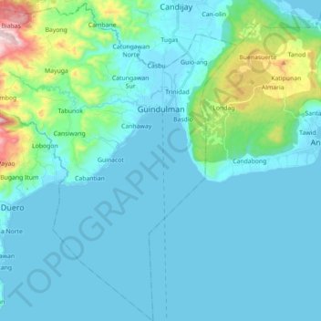
Name: Guindulman topographic map, elevation, terrain.
Location: Guindulman, Bohol, Central Visayas, Philippines (9.64675 124.38146 9.82088 124.53009)
Average elevation: 77 m
Minimum elevation: -3 m
Maximum elevation: 573 m
Other topographic maps
Click on a map to view its topography, its elevation and its terrain.
Cabantian
Philippines > Bohol > Guindulman
Cabantian, Guindulman, Bohol, Central Visayas, Philippines
Average elevation: 52 m