
Agusan River topographic map
Interactive map
Click on the map to display elevation.
About this map
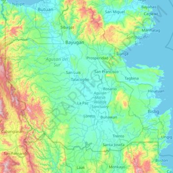
Name: Agusan River topographic map, elevation, terrain.
Location: Agusan River, Agusan del Sur, Caraga, Philippines (7.77853 125.51878 9.01349 126.07960)
Average elevation: 238 m
Minimum elevation: 0 m
Maximum elevation: 1,599 m
Other topographic maps
Click on a map to view its topography, its elevation and its terrain.
Sibagat
Philippines > Agusan del Sur > Sibagat
Sibagat is located at 8°49′N 125°41′E / 8.82°N 125.69°E / 8.82; 125.69. Elevation of most areas of the municipality sit atop 100 meters above sea level (M.a.s.l.).
Average elevation: 147 m