
Make a donation
Batong Malake topographic map
Click on the map to display elevation.
Make a donation
About this map
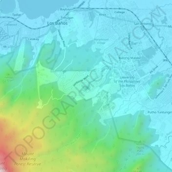
Name: Batong Malake topographic map, elevation, terrain.
Average elevation: 93 m
Minimum elevation: 1 m
Maximum elevation: 458 m
Make a donation
Other topographic maps
Click on a map to view its topography, its elevation and its terrain.
Mount Makiling
Philippines > Laguna > Los Baños
Mount Makiling (also spelled Maquiling) is an inactive stratovolcano located in the provinces of Laguna and Batangas on the island of Luzon in the Philippines. The mountain rises to an elevation of 1,090 meters (3,580 ft) above mean sea level and is the highest feature of the Laguna Volcanic Field. The volcano…
Average elevation: 753 m
Make a donation
Mount Makiling
Philippines > Laguna > Los Baños
Mount Makiling (also spelled Maquiling) is an inactive stratovolcano located in the provinces of Laguna and Batangas on the island of Luzon in the Philippines. The mountain rises to an elevation of 1,090 meters (3,580 ft) above mean sea level and is the highest feature of the Laguna Volcanic Field. The volcano…
Average elevation: 753 m
Make a donation