
Rust topographic map
Interactive map
Click on the map to display elevation.
About this map
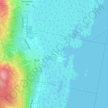
Name: Rust topographic map, elevation, terrain.
Location: Rust, Burgenland, 7071, Austria (47.78178 16.64203 47.82588 16.73178)
Average elevation: 126 m
Minimum elevation: 110 m
Maximum elevation: 221 m
Other topographic maps
Click on a map to view its topography, its elevation and its terrain.
Wiesen
Austria > Burgenland > Wiesen
Wiesen, Bezirk Mattersburg, Burgenland, 7203, Austria
Average elevation: 375 m
Lake Neusiedl
Austria > Burgenland > Rust
Lake Neusiedl, Ruster Bucht, Rust, Burgenland, 7071, Austria
Average elevation: 147 m