
Tasmania topographic map
Interactive map
Click on the map to display elevation.
About this map
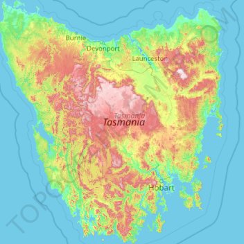
Name: Tasmania topographic map, elevation, terrain.
Location: Tasmania, Australia (-43.64304 144.60734 -40.64139 148.35910)
Average elevation: 220 m
Minimum elevation: -3 m
Maximum elevation: 1,524 m
The most mountainous region is the Central Highlands area, which covers most of the central western parts of the state. The Midlands located in the central east, is fairly flat, and is predominantly used for agriculture, although farming activity is scattered throughout the state. Tasmania's tallest mountain is Mount Ossa at 1,617 m (5,305 ft). Much of Tasmania is still densely forested, with the Southwest National Park and neighbouring areas holding some of the last temperate rain forests in the Southern Hemisphere. The Tarkine, containing Savage River National Park located in the island's far north west, is the largest temperate rainforest area in Australia covering about 3,800 square kilometres (1,500 sq mi). With its rugged topography, Tasmania has a great number of rivers. Several of Tasmania's largest rivers have been dammed at some point to provide hydroelectricity. Many rivers begin in the Central Highlands and flow out to the coast. Tasmania's major population centres are mainly situated around estuaries (some of which are named rivers).
Other topographic maps
Click on a map to view its topography, its elevation and its terrain.
Launceston
Australia > Tasmania > Launceston
Launceston, Tasmania, 7250, Australia
Average elevation: 218 m
Cradle Mountain
Australia > Tasmania > Cradle Mountain
Cradle Mountain, Cradle Mount Summit Track, Cradle Mountain, Meander Valley, Tasmania, Australia
Average elevation: 1,144 m
Mount Lloyd
Mount Lloyd, Derwent Valley, Tasmania, 7140, Australia
Average elevation: 558 m
West Kentish
West Kentish, Kentish, Tasmania, 7306, Australia
Average elevation: 291 m
West Ulverstone
Australia > Tasmania > Ulverstone
West Ulverstone, Ulverstone, Central Coast, Tasmania, 7315, Australia
Average elevation: 26 m
Connellys Marsh
Connellys Marsh, Sorell, Tasmania, 7173, Australia
Average elevation: 41 m
Mount Direction
Mount Direction, Hobart, City of Clarence, Tasmania, 7017, Australia
Average elevation: 166 m
Styx River
Australia > Tasmania > Westerway
Styx River, Westerway, Derwent Valley, Tasmania, Australia
Average elevation: 548 m
West Montagu
West Montagu, Circular Head, Tasmania, 7330, Australia
Average elevation: 35 m
Bruny Island
Australia > Tasmania > Alonnah
Bruny Island, Alonnah, Kingborough, Tasmania, Australia
Average elevation: 59 m
Arthurs Lake
Arthurs Lake, Central Highlands, Tasmania, 7030, Australia
Average elevation: 910 m
Garden Island Creek
Garden Island Creek, Huon Valley, Tasmania, 7112, Australia
Average elevation: 153 m
Lower Turners Marsh
Lower Turners Marsh, City of Launceston, Tasmania, 7267, Australia
Average elevation: 141 m
Lower Longley
Lower Longley, Hobart, Kingborough, Tasmania, 7109, Australia
Average elevation: 338 m
Launceston
Launceston, City of Launceston, Tasmania, Australia
Average elevation: 194 m
Greens Beach
Greens Beach, West Tamar, Tasmania, 7270, Australia
Average elevation: 30 m
Launceston
Launceston, City of Launceston, Tasmania, 7250, Australia
Average elevation: 26 m
Claude Road
Claude Road, Kentish, Tasmania, 7306, Australia
Average elevation: 444 m
Black Hills
Black Hills, Derwent Valley, Tasmania, 7140, Australia
Average elevation: 432 m
Chain Of Lagoons
Chain Of Lagoons, Break O'Day, Tasmania, 7215, Australia
Average elevation: 154 m
Deddington
Deddington, Northern Midlands, Tasmania, 7212, Australia
Average elevation: 358 m
Selfs Point
Selfs Point, New Town, Hobart, City of Hobart, Tasmania, 7008, Australia
Average elevation: 17 m
Mount Wellington
Mount Wellington, City of Hobart, Tasmania, Australia
Average elevation: 941 m
Lake Murchison
Australia > Tasmania > Tullah > Lake St Clair
Lake Murchison, Lake St Clair, Tullah, West Coast, Tasmania, Australia
Average elevation: 531 m
Lower Barrington
Lower Barrington, Kentish, Tasmania, 7306, Australia
Average elevation: 202 m
Barrington
Barrington, Kentish, Tasmania, 7306, Australia
Average elevation: 228 m
Nowhere Else
Nowhere Else, Kentish, Tasmania, 7306, Australia
Average elevation: 279 m