
Thank you for supporting this site ❤️
Make a donation
Make a donation
Hampstead Heath topographic map
Click on the map to display elevation.
Thank you for supporting this site ❤️
Make a donation
Make a donation
About this map
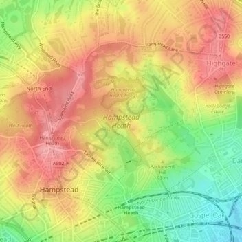
Name: Hampstead Heath topographic map, elevation, terrain.
Average elevation: 94 m
Minimum elevation: 35 m
Maximum elevation: 136 m
Thank you for supporting this site ❤️
Make a donation
Make a donation
Other topographic maps
Click on a map to view its topography, its elevation and its terrain.
Thank you for supporting this site ❤️
Make a donation
Make a donation
Thank you for supporting this site ❤️
Make a donation
Make a donation
Thank you for supporting this site ❤️
Make a donation
Make a donation
London Borough of Bromley
United Kingdom > England > London
Westerham Heights, the highest point in London and Kent at an altitude of 804 feet (245 m), is on the southern boundary. The Prime Meridian passes through Bromley.
Average elevation: 104 m
Thank you for supporting this site ❤️
Make a donation
Make a donation
Thank you for supporting this site ❤️
Make a donation
Make a donation