
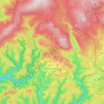
Sankt Andreasberg topographic map
Interactive map
Click on the map to display elevation.
About this map
Name: Sankt Andreasberg topographic map, elevation, terrain.
Average elevation: 648 m
Minimum elevation: 347 m
Maximum elevation: 914 m
Other topographic maps
Click on a map to view its topography, its elevation and its terrain.
Hohegeiß
Duitsland > Nedersaksen > Landkreis Goslar > Braunlage
Hohegeiß, Braunlage, Landkreis Goslar, Nedersaksen, Duitsland
Average elevation: 568 m