
Thank you for supporting this site ❤️
Make a donation
Make a donation
Pontevedra topographic map
Click on the map to display elevation.
Thank you for supporting this site ❤️
Make a donation
Make a donation
About this map
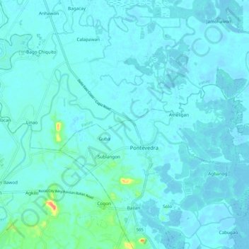
Name: Pontevedra topographic map, elevation, terrain.
Location: Pontevedra, Capiz, Western Visayas, 5815, Philippines (11.47050 122.78543 11.51212 122.89021)
Average elevation: 6 m
Minimum elevation: -2 m
Maximum elevation: 69 m
Thank you for supporting this site ❤️
Make a donation
Make a donation
Other topographic maps
Click on a map to view its topography, its elevation and its terrain.
Thank you for supporting this site ❤️
Make a donation
Make a donation
Thank you for supporting this site ❤️
Make a donation
Make a donation
Mount Nangtud
Philippines > Capiz > Jamindan
Mount Nangtud is the second highest peak on the island of Panay, in the Philippines and third highest mountain in the Visayas, after Mount Kanlaon and Mount Madja-as. With an elevation of 2,074 m (6,804 ft) above sea level, it is located geographically within Jamindan, Capiz bordering with Barbaza, Antique.…
Average elevation: 1,578 m
Thank you for supporting this site ❤️
Make a donation
Make a donation
Thank you for supporting this site ❤️
Make a donation
Make a donation
Thank you for supporting this site ❤️
Make a donation
Make a donation
Thank you for supporting this site ❤️
Make a donation
Make a donation
Thank you for supporting this site ❤️
Make a donation
Make a donation
Thank you for supporting this site ❤️
Make a donation
Make a donation
Thank you for supporting this site ❤️
Make a donation
Make a donation
Thank you for supporting this site ❤️
Make a donation
Make a donation
Thank you for supporting this site ❤️
Make a donation
Make a donation
Thank you for supporting this site ❤️
Make a donation
Make a donation
Thank you for supporting this site ❤️
Make a donation
Make a donation
Thank you for supporting this site ❤️
Make a donation
Make a donation
Thank you for supporting this site ❤️
Make a donation
Make a donation
Thank you for supporting this site ❤️
Make a donation
Make a donation
Thank you for supporting this site ❤️
Make a donation
Make a donation
Thank you for supporting this site ❤️
Make a donation
Make a donation
Thank you for supporting this site ❤️
Make a donation
Make a donation
Thank you for supporting this site ❤️
Make a donation
Make a donation