
Leyte topographic map
Interactive map
Click on the map to display elevation.
Leyte
Mahagnao Volcano Natural Park Located in Burauen, Leyte, about 66 km (41 mi) from Tacloban City, the Mahagnao Volcano Natural Park attracts visitors with its lakes, craters, hot springs, multi-colored mud, virgin forests and lagoon. It was proclaimed as a national park in 1937. Like other regions in the Philippines, the area enjoys a temperate climate. It has an elevation of 1,200 meters above sea level and an area of 635 hectares, within the boundaries of Burauen, La Paz and McArthur towns.
About this map
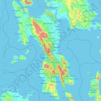
Name: Leyte topographic map, elevation, terrain.
Location: Leyte, Eastern Visayas, Philippines (10.00448 124.28589 11.56351 125.26800)
Average elevation: 68 m
Minimum elevation: -1 m
Maximum elevation: 1,238 m
Other topographic maps
Click on a map to view its topography, its elevation and its terrain.