
Santa Barbara topographic map
Interactive map
Click on the map to display elevation.
About this map
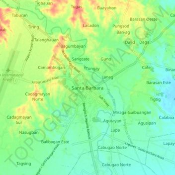
Name: Santa Barbara topographic map, elevation, terrain.
Location: Santa Barbara, Iloilo, Western Visayas, 5002, Philippines (10.78723 122.49147 10.86723 122.57147)
Average elevation: 34 m
Minimum elevation: 10 m
Maximum elevation: 79 m
The topography of Santa Barbara varies from slightly rolling hills to almost flat or gradually inclined plains, sliced by Tigum River at its centremost, which flows from the north-west to the southeast and the Aganan River in the southern section.