
Thank you for supporting this site ❤️
Make a donation
Make a donation
Talim topographic map
Click on the map to display elevation.
Thank you for supporting this site ❤️
Make a donation
Make a donation
About this map
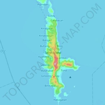
Name: Talim topographic map, elevation, terrain.
Location: Talim, Binangonan, Rizal, Calabarzon, Philippines (14.28701 121.21394 14.42266 121.26637)
Average elevation: 13 m
Minimum elevation: -5 m
Maximum elevation: 411 m
Thank you for supporting this site ❤️
Make a donation
Make a donation
Other topographic maps
Click on a map to view its topography, its elevation and its terrain.
Mount Tagapo
Philippines > Rizal > Binangonan
Mount Tagapo, also known as Susong Dalaga, is a conical peak on the lake island of Talim on Laguna de Bay, the largest lake in the Philippines. The mountain ridge is 438 m (1,437 ft) in elevation and the highest point of Talim Island. The peak falls under the respective jurisdictions of the towns of Binangonan…
Average elevation: 112 m
Thank you for supporting this site ❤️
Make a donation
Make a donation
Thank you for supporting this site ❤️
Make a donation
Make a donation
Thank you for supporting this site ❤️
Make a donation
Make a donation
Thank you for supporting this site ❤️
Make a donation
Make a donation
Thank you for supporting this site ❤️
Make a donation
Make a donation
Thank you for supporting this site ❤️
Make a donation
Make a donation