
Drummondville topographic map
Interactive map
Click on the map to display elevation.
About this map
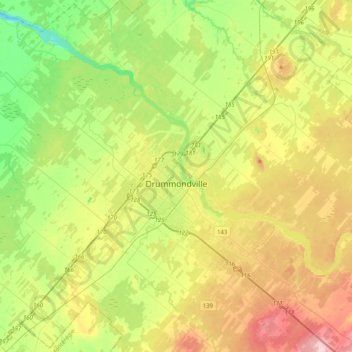
Name: Drummondville topographic map, elevation, terrain.
Location: Drummondville, Drummond, Centre-du-Québec, Quebec, Canada (45.75304 -72.65524 46.03167 -72.26763)
Average elevation: 86 m
Minimum elevation: 14 m
Maximum elevation: 193 m
Other topographic maps
Click on a map to view its topography, its elevation and its terrain.
Saint-Germain-de-Grantham
Saint-Germain-de-Grantham, Drummond, Centre-du-Québec, Quebec, J0C 1K0, Canada
Average elevation: 84 m
Saint-Lucien
Saint-Lucien, Drummond, Centre-du-Québec, Quebec, J0C 1N0, Canada
Average elevation: 113 m