
Carcar topographic map
Interactive map
Click on the map to display elevation.
About this map
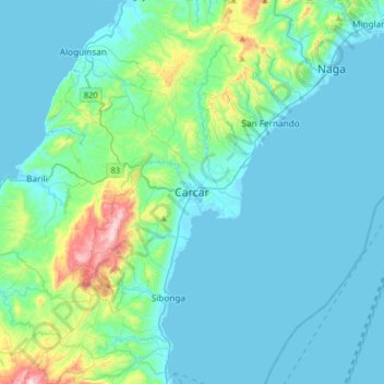
Name: Carcar topographic map, elevation, terrain.
Location: Carcar, Cebu, Central Visayas, 6019, Philippines (9.94556 123.48067 10.26556 123.80067)
Average elevation: 97 m
Minimum elevation: -1 m
Maximum elevation: 698 m
The land is generally level with less than 18% slope comprising 78.7% of the total land area. Areas with slopes ranging from 18 to 50% cover 19.3% of the total land area and those over 50% slope comprise approximately 1.9%. The highest recorded elevation is a little over 660 metres (2,170 ft) above sea level, located within the barangay of Napo.
Other topographic maps
Click on a map to view its topography, its elevation and its terrain.
Cebu City
Philippines > Cebu > Cebu City
Cebu City, Cebu, Central Visayas, 6000, Philippines
Average elevation: 140 m
Damolog
Philippines > Cebu > Sogod
Damolog, Sogod, Cebu, Central Visayas, 6007, Philippines
Average elevation: 70 m
Basak
Philippines > Cebu > Badian
Basak, Badian, Cebu, Central Visayas, 6031, Philippines
Average elevation: 305 m
Yati
Philippines > Cebu > Liloan
Yati, Liloan, Cebu, Central Visayas, 6002, Philippines
Average elevation: 14 m
Caurasan
Philippines > Cebu > Carmen
Caurasan, Carmen, Cebu, Central Visayas, Philippines
Average elevation: 531 m
Dawis Sur
Dawis Sur, Cebu, Central Visayas, 6005, Philippines
Average elevation: 20 m
Cogon
Philippines > Cebu > Cordova
Cogon, Cordova, Cebu, Central Visayas, 6017, Philippines
Average elevation: 2 m
Bantayan Island
Philippines > Cebu > Sungko
Bantayan Island, Sungko, Cebu, Central Visayas, Philippines
Average elevation: 5 m
Tagjaguimit
Tagjaguimit, Cebu, Central Visayas, Philippines
Average elevation: 296 m
Maghaway
Philippines > Cebu > Talisay
Maghaway, Talisay, Cebu, Central Visayas, 6045, Philippines
Average elevation: 122 m
Basdiot
Philippines > Cebu > Moalboal
Basdiot, Moalboal, Cebu, Central Visayas, 6032, Philippines
Average elevation: 5 m
Tubod-Bitoon
Philippines > Cebu > Dumanjug
Tubod-Bitoon, Dumanjug, Cebu, Central Visayas, 6035, Philippines
Average elevation: 82 m
Cadulawan
Philippines > Cebu > Minglanilla
Cadulawan, Minglanilla, Cebu, Central Visayas, 6046, Philippines
Average elevation: 98 m
Lanipga
Philippines > Cebu > Consolacion
Lanipga, Consolacion, Cebu, Central Visayas, Philippines
Average elevation: 216 m
Maravilla Public Beach
Philippines > Cebu > Maravilla
Maravilla Public Beach, Maravilla, Cebu, Central Visayas, Philippines
Average elevation: 24 m
Badian Island
Philippines > Cebu > Zaragosa
Badian Island, Zaragosa, Cebu, Central Visayas, Philippines
Average elevation: 7 m
Jumangpas
Philippines > Cebu > Samboan
Jumangpas, Samboan, Cebu, Central Visayas, 6027, Philippines
Average elevation: 423 m
Bagalnga
Philippines > Cebu > Compostela
Bagalnga, Compostela, Cebu, Central Visayas, 6003, Philippines
Average elevation: 90 m
Nalusuan Island
Philippines > Cebu > Cordova > Gilutongan
Nalusuan Island, Gilutongan, Cordova, Cebu, Central Visayas, Philippines
Average elevation: 0 m
Tinabyonan
Tinabyonan, Cebu, Central Visayas, 6006, Philippines
Average elevation: 304 m
Mananga River
Philippines > Cebu > Talisay
Mananga River, Talisay, Cebu, Central Visayas, Philippines
Average elevation: 17 m
Olango Island
Philippines > Cebu > Lapu-Lapu
Olango Island, Lapu-Lapu, Cebu, Central Visayas, Philippines
Average elevation: 2 m
Valencia
Valencia, Cebu, Central Visayas, 6019, Philippines
Average elevation: 152 m
Consolacion
Consolacion, Cebu, Central Visayas, 6001, Philippines
Average elevation: 31 m
Busay
Philippines > Cebu > Busay
Busay, Cebu, Central Visayas, 6000, Philippines
Average elevation: 225 m
Cebu
Philippines > Cebu > Cebu City
Cebu, Cebu City, Cebu, Central Visayas, Philippines
Average elevation: 103 m
Busay
Philippines > Cebu > Moalboal
Busay, Moalboal, Cebu, Central Visayas, 6033, Philippines
Average elevation: 151 m