
Palo Alto County topographic map
Interactive map
Click on the map to display elevation.
About this map
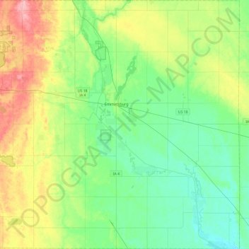
Name: Palo Alto County topographic map, elevation, terrain.
Location: Palo Alto County, Iowa, United States (42.90680 -94.91601 43.25561 -94.44340)
Average elevation: 383 m
Minimum elevation: 347 m
Maximum elevation: 465 m
Other topographic maps
Click on a map to view its topography, its elevation and its terrain.
Iowa City
United States > Iowa > Johnson County
Iowa City, Johnson County, Iowa, United States
Average elevation: 216 m
Alta Vista
United States > Iowa > Chickasaw County
Alta Vista, Chickasaw County, Iowa, United States
Average elevation: 360 m
Newton
United States > Iowa > Jasper County
Newton, Jasper County, Iowa, 50208, United States
Average elevation: 277 m
Slater
United States > Iowa > Story County
Slater, Story County, Iowa, United States
Average elevation: 316 m
Welton
United States > Iowa > Clinton County
Welton, Clinton County, Iowa, United States
Average elevation: 221 m
Rockwell
United States > Iowa > Cerro Gordo County
Rockwell, Cerro Gordo County, Iowa, United States
Average elevation: 343 m
Windsor Heights
United States > Iowa > Polk County
Windsor Heights, Polk County, Iowa, 50324, United States
Average elevation: 272 m
Atlantic
United States > Iowa > Cass County > Atlantic
Atlantic, Cass County, Iowa, 50022, United States
Average elevation: 369 m
West Des Moines
United States > Iowa > Polk County > West Des Moines
West Des Moines, Polk County, Iowa, United States
Average elevation: 280 m
Des Moines
United States > Iowa > Polk County
Des Moines, Polk County, Iowa, United States
Average elevation: 264 m