
Green Meadows topographic map
Interactive map
Click on the map to display elevation.
About this map
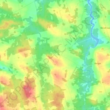
Name: Green Meadows topographic map, elevation, terrain.
Location: Green Meadows, Kings County, Prince Edward Island, Canada (46.33413 -62.76417 46.40884 -62.69039)
Average elevation: 32 m
Minimum elevation: 0 m
Maximum elevation: 71 m
Other topographic maps
Click on a map to view its topography, its elevation and its terrain.
Mount Stewart
Canada > Prince Edward Island > Kings County
Mount Stewart, Kings County, Prince Edward Island, Canada
Average elevation: 38 m