
City of White Plains topographic map
Interactive map
Click on the map to display elevation.
About this map
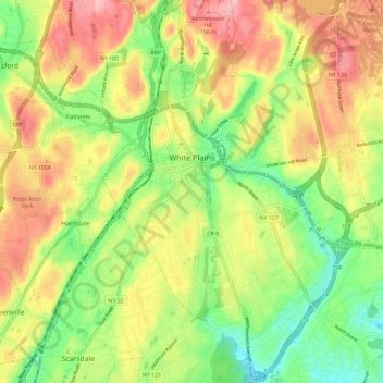
Name: City of White Plains topographic map, elevation, terrain.
Average elevation: 83 m
Minimum elevation: 16 m
Maximum elevation: 158 m
Other topographic maps
Click on a map to view its topography, its elevation and its terrain.
Shrub Oak
United States > New York > Westchester County > Town of Yorktown
Shrub Oak, Town of Yorktown, Westchester County, New York, 10588, United States
Average elevation: 156 m
Village of Ossining
United States > New York > Westchester County > Town of Ossining
Village of Ossining, Town of Ossining, Westchester County, New York, 10562, United States
Average elevation: 61 m
Lake Mohegan
United States > New York > Westchester County > Town of Yorktown
Lake Mohegan, Town of Yorktown, Westchester County, New York, 10547, United States
Average elevation: 140 m
Village of Pleasantville
United States > New York > Westchester County
Village of Pleasantville, Town of Mount Pleasant, Westchester County, New York, 10570, United States
Average elevation: 124 m