
Calubian topographic map
Interactive map
Click on the map to display elevation.
About this map
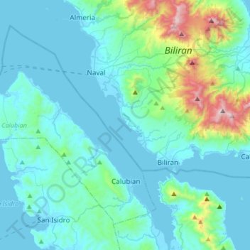
Name: Calubian topographic map, elevation, terrain.
Average elevation: 148 m
Minimum elevation: -1 m
Maximum elevation: 1,110 m
Other topographic maps
Click on a map to view its topography, its elevation and its terrain.
Cristina
Philippines > Leyte > Calubian
Cristina, Calubian, Leyte 3rd District, Leyte, Eastern Visayas, 6534, Philippines
Average elevation: 69 m