
Kalayaan topographic map
Interactive map
Click on the map to display elevation.
Kalayaan
Kalayaan is roughly rectangular in shape, with a hilly terrain on most of its eastern side, while relatively flat on its western side. Its highest elevations are from 400 to 418 metres. These are found in Sitio Santo Angel, Malaking Pulo, and Cabuhayan in Barangay San Juan, and Sitio Lamao in Barangay San Antonio. Approximately three fourths of the total land area are with terrain 300 metres above sea level. Its lowest points are from 5 to 20 metres along the western sections of Barangays San Juan and Longos towards Laguna de Bay.
About this map
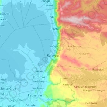
Name: Kalayaan topographic map, elevation, terrain.
Location: Kalayaan, Laguna, Calabarzon, 4015, Philippines (14.30808 121.46175 14.35190 121.61449)
Average elevation: 159 m
Minimum elevation: -3 m
Maximum elevation: 526 m
Other topographic maps
Click on a map to view its topography, its elevation and its terrain.
Mount San Cristobal
Philippines > Laguna > Rizal
Mount San Cristobal is a potentially active stratovolcano at the boundary of the provinces of Laguna and Quezon on the island of Luzon, Philippines. The mountain rises to an elevation of 1,470 m (4,820 ft) above mean sea level and is one of the volcanic features of Macolod Corridor.
Average elevation: 1,021 m
Mount Makiling
Philippines > Laguna > Los Baños
Mount Makiling (also spelled Maquiling) is an inactive stratovolcano located in the provinces of Laguna and Batangas on the island of Luzon in the Philippines. The mountain rises to an elevation of 1,090 meters (3,580 ft) above mean sea level and is the highest feature of the Laguna Volcanic Field. The volcano…
Average elevation: 753 m