
Lumajang topographic map
Interactive map
Click on the map to display elevation.
About this map
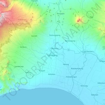
Name: Lumajang topographic map, elevation, terrain.
Location: Lumajang, East Java, Java, Indonesia (-8.35110 112.90076 -7.89604 113.37959)
Average elevation: 344 m
Minimum elevation: 0 m
Maximum elevation: 2,618 m
Other topographic maps
Click on a map to view its topography, its elevation and its terrain.
Penanggungan
Indonesia > East Java > Mojokerto > Penanggungan
Penanggungan, Mojokerto, East Java, Indonesia
Average elevation: 645 m
Gunung Lawu
Indonesia > East Java > Madiun
Gunung Lawu, Madiun, East Java, Indonesia
Average elevation: 2,881 m